
Are you an Android developer and love the site? Contact us
updated (Apr 14, 2024)
What are PIREPs?
Updated November 14, 2023
As you can see in our US map options, there is one that lists Pilot Reports or PIREPs. What are those and where do they come from? And why are they important?
PIREPS, as the name implies, are reports of weather and flight conditions that pilots provide from along their route during flight. Pilots report general conditions, not just if they encounter adverse conditions or turbulence. These reports are some of the most important and helpful tools in aviation for several different reasons:
- They provide direct input to pilots that are flying into a specific area, and to dispatchers and air traffic controllers that are planning and routing air traffic. For example, if a pilot learns that there is moderate turbulence ahead at the current flight level, they can request to move higher or lower to avoid the rough air. Conversely, if turbulence was forecast for an area, but several flights report smooth conditions, forecasts and flight plans can be adjusted.
- PIREPs indicate actual conditions in the air, which can be different from what was forecast, and impossible to discern for forecasters from the ground (for example over an ocean).
- They help weather forecasting agencies issue or discontinue hazardous weather advisories, such as AIRMETs (Airman’s Meteorological Information) or SIGMETs (Significant Meteorological Information) for a specific area and flight level, or change the existing notices.
- PIREPs provide valuable data that is used to improve global weather modeling and forecasting systems and algorithms.
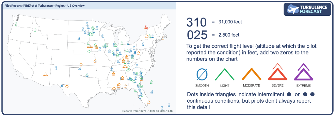
If you look at the map, you just see small symbols and numbers indicating the flight condition at a specific altitude. How does the information get onto the map? Pilots follow a chart to report all the important data. Charts that pilots use have more information than the one provided for you, where we show the turbulence information only. The PIREP itself just looks like a jumble of numbers and letters. Here is a PIREP example:
UA /OV KOKC /TM 1551 /FL144 /TP A319 /WV 24540KT /TB LGT /RM IN CLR
What does that mean? Let’s break it down:
UA – routine (not urgent) Upper Air observation. (Code UUA would mean it’s an urgent message, for example for severe turbulence.)
OV – over Oklahoma, OK airport
TM – the time is 15:51 Zulu
FL – the flight level is 14,400 feet
TP – the aircraft type is an Airbus 319
WV – the wind direction is 245° at 40 kt
TB – there is light turbulence
RM – remarks say that the flight is in clear skies
The first 5 data points here are required of all PIREPs. The pilot has a total of 12 categories that they can use to report. On top of the ones we have seen here, pilots could report on SK (sky cover), WX (visibility and weather), TA (temperature), IC (icing), and they can add more information in the RM (remarks) section.
In addition to PIREPs, modern planes also send automated AIREPs (Air Reports) that are generated by the on-board computer, and transmitted via radio to ground stations. AIREPs use latitude and longitude location data of where the plane is at that moment.
So next time your pilot announces that they will turn on the seatbelt sign in 5 minutes, it might have been because the plane ahead of you let them know it might be a bit bumpy for a few minutes.