Home
World Map
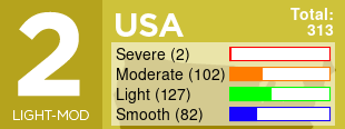
USA
Turbulence Advisories
Pilot Reports
Max Turbulence Potential
Storms/Convection
Radar/Echo Tops
Surface Analysis
Surface Winds
Weather Maps
Alaska
200mb Analysis
200mb Forecast
250mb Analysis
500mb Analysis
Archive
International
Canada
Canada Mexico 250mb
Atlantic and Europe 1
Europe 2
Europe 200mb Forecast
Europe 250mb
Transatlantic Eastbound
Transatlantic Westbound
South America & Africa
Australia, Asia/Pacific
Hawaii, Japan, Asia/Pacific
India & Middle East
Polar Route Asia Pacific
Polar Route Europe Atlantic
Polar Atlantic
Jet Stream
More
Support/Pledge
World Turbulence Explorer
TF App for iOS
Other Sites
Like on Facebook
Fear of Flying Help
Fear of Flying Book
Map Help
Comments / Feedback
Search
Forecast Via Email
Login/Register
Blog
FAQ
Are you an Android developer and love the site? Contact us
updated (Apr 14, 2024)
Error 404
The page you are looking for does not exist.